 | 10.1:
Here are teaching slides for "Ice-sheet dynamics and the glacial sedimentary
record".
You can see a full-size version by clicking on the thumbnail. You can then
download that slide individually by right mouse clicking on it; using the "Save
As" command in the File menu; or in most cases, by simply dragging it to your
desktop.
|
|
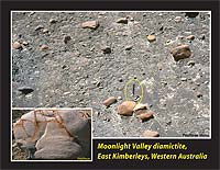 | 10.2:
Boulder-claystone (diamictite) with glacially scratched boulders of quartzite
(inset) and dolomite in the Moonlight Valley Tillite, East Kimberleys,
Western Australia. Sedimentology suggests the former existence of dynamic
wet-base ice.
|
|
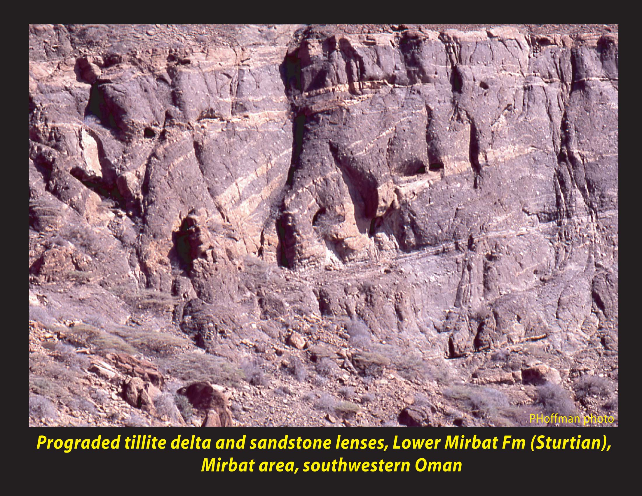
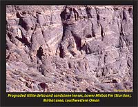 | 10.3:
Prograded till “delta” with sandstone lenses in the Lower Mirbat
Formation (Sturtian?), Mirbat inlier, southwestern Oman. Sedimentology
suggests subglacial meltwater production.
|
|
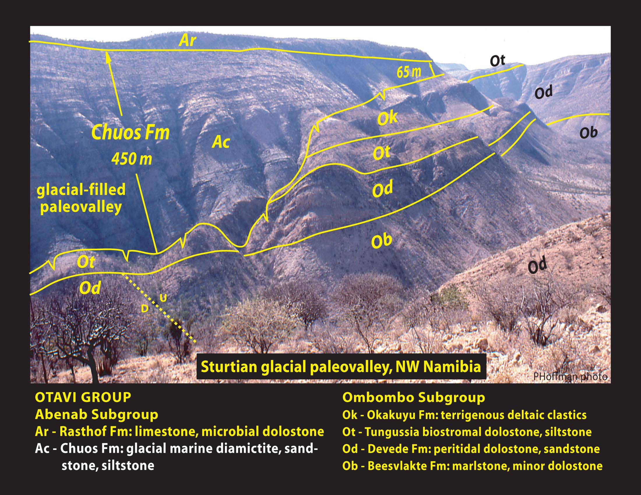
 | 10.4:
Glacially-filled paleovalley from the older Cryogenian (Sturtian) glaciation
in the Otavi Group, NW Namibia. Chuos Formation diamictite and sandstone
thickens from 65 to 450 m in 2.5 km along strike at the expense of underlying
strata (Ombombo Subgroup), which were tectonically rotated 1.5Å during
the glaciation.
|
|
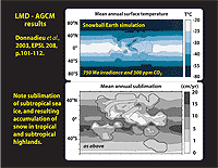 | 10.5:
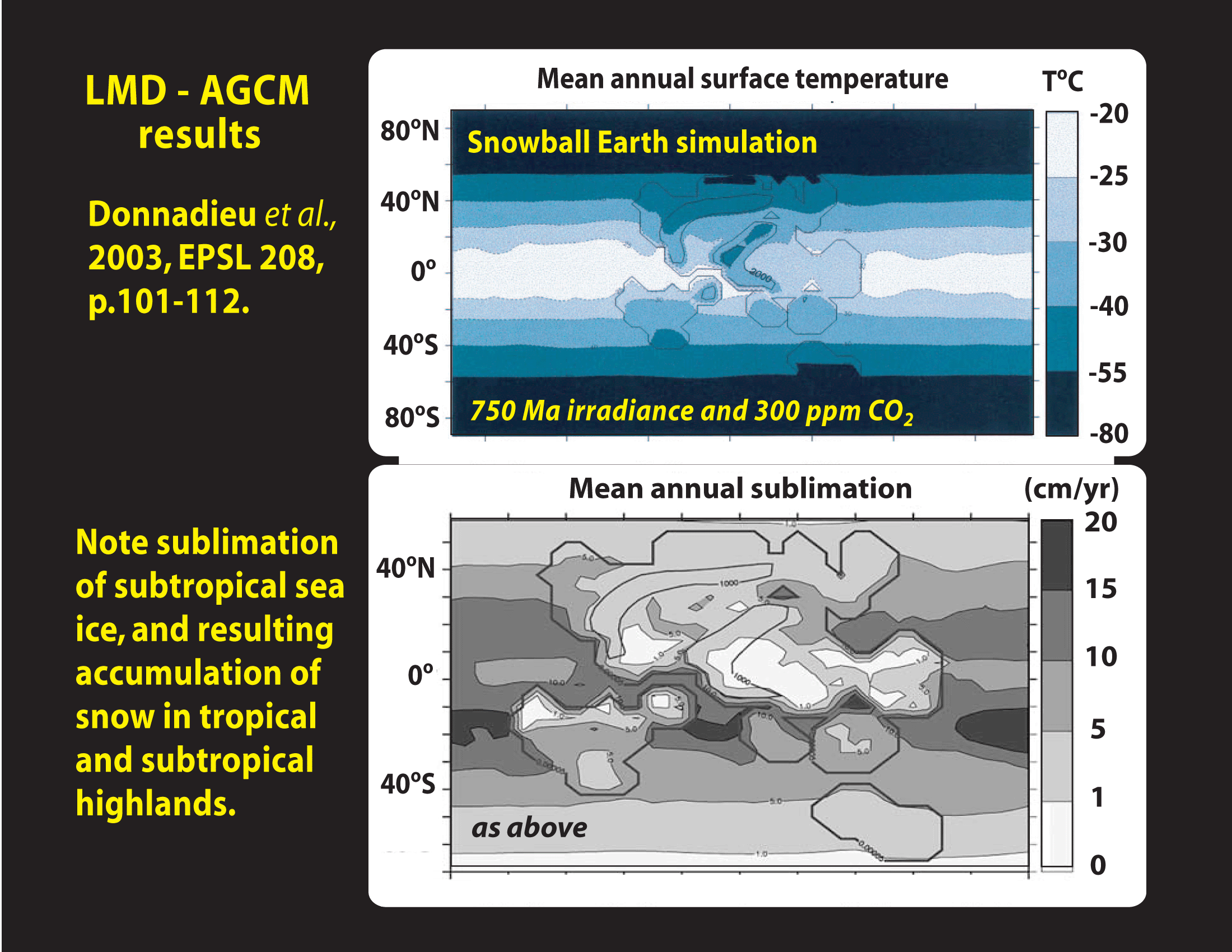
Mean annual surface temperatures and sublimation rates in an AGCM simulation
of a snowball earth with 750 Ma paleogeography (Donnadieu et al., 2003).
Note extensive sublimation of sea ice, strongest in the subtropics, and
comensurate accumulation of condensate in tropical and subtropical highlands.
|
|
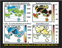 | 10.6:
Simulations using an AGCM for 750 Ma with coupled sea-ice and ice-sheet
dynamics (Donnadieu et al., 2003): (A) with 900 ppm 2, land-based ice
sheets build up but the ocean remains open; (B) with 300 ppm CO2, ocean
is completely ice covered but land-based ice sheets continue to grow, covering
most global land area by 400 kyr after snowball onset; (C) same as (B)
showing basal temperature of land-based ice sheets; (D) same as (B) showing
basal sliding velocities of land-based ice sheets. Note the narrow corridors
of fast-flowing wet-base ice (ice streams) near the margins of the tropical
ice sheets.
|
|
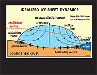 | 10.7:
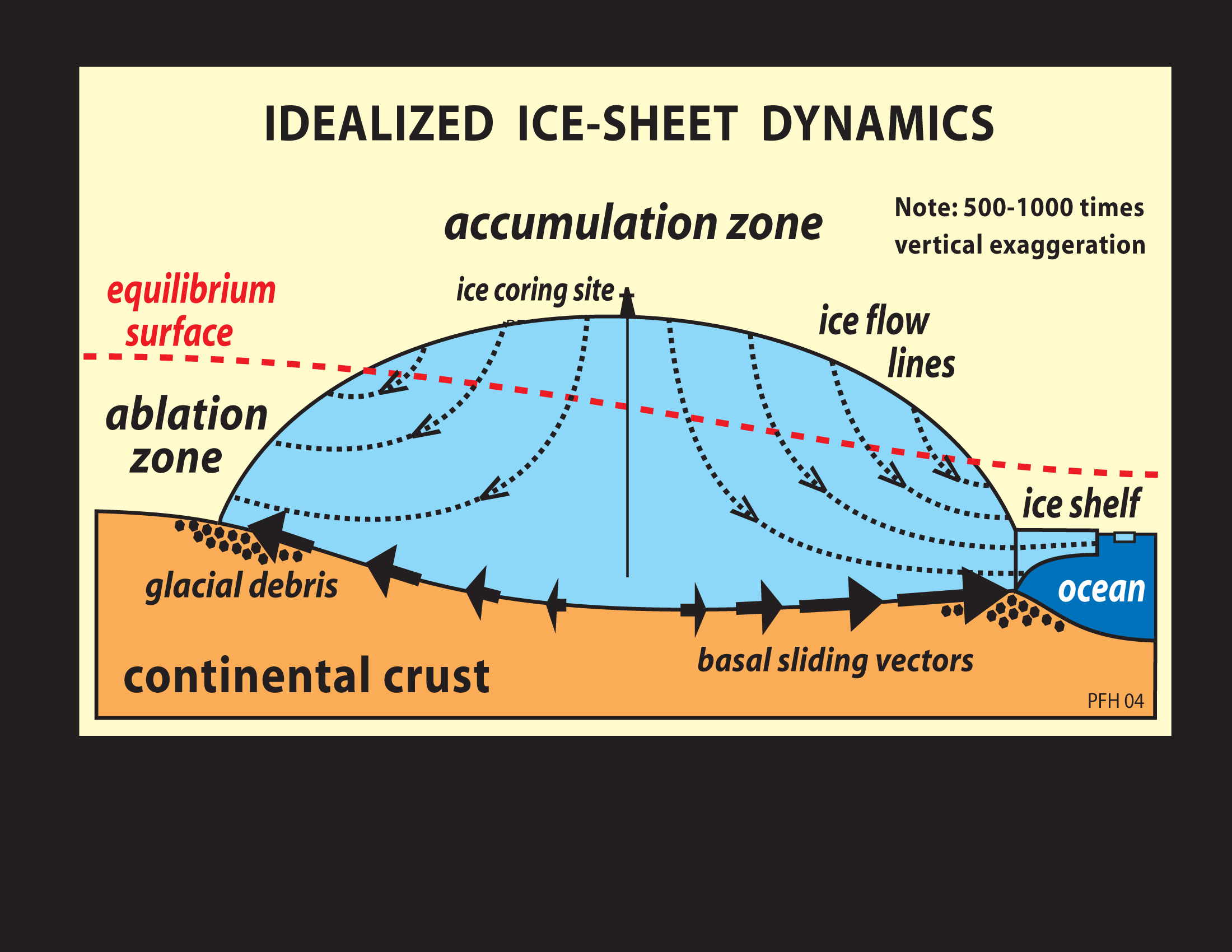
Dynamics of an idealized ice sheet, showing flowage from a central area
of accumulation to a peripheral zone of ablation. Note vertical exaggeration.
|
|
 | 10.8:
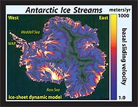
Simulated basal sliding velocities for the present Antarctic Ice Sheet,
displaying narrow corridors of fast-flowing wet-base ice (ice streams)
within the cold-base peripheral zone. Up to 90% of the total ice-sheet
drainage is thought to be routed through ice streams.
|
|
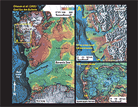 | 10.9:
Bathymetry of the Barents Sea region of Arctic Europe, displaying transverse
troughs with trough-mouth fans or moraines, inferred as having formed through
the action of Quaternary ice streams (Ottesen et al., 2005). Troughs range
from a few 100’s to a few 10’s of km in width, and 10’s
of m in depth. They attest to the erosive potency of ice streams.
|
|
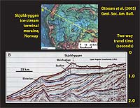 | 10.10:
Seismic-reflection profile oriented perpendicular to the Skjoldryggen ice-stream
terminal moraine on the western Norwegian margin (Ottesen et al., 2005).
|
|
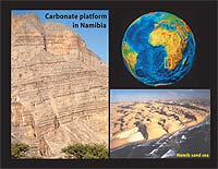 | 10.11:
Cryogenian carbonate platform (Otavi Group) exposed on the Great Western
Escarpment of southern Africa in northern Namibia.
|
|
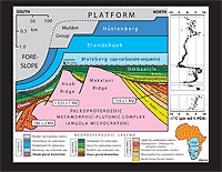
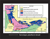 | 10.12:
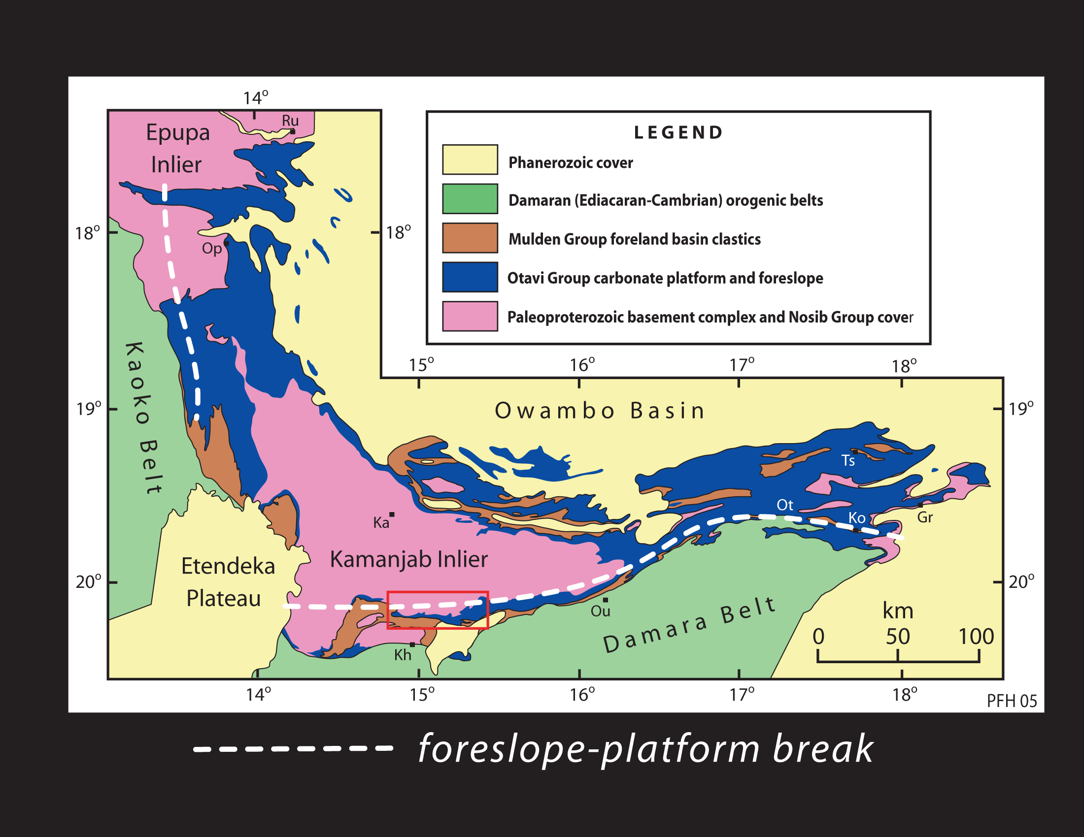
Geological map of the Otavi Group carbonate platform and foreslope of Cryogenian
and early Ediacaran age (ca 780-580 Ma), northern Namibia. Red box encloses
part of the southern foreslope known as the Fransfontein Ridge.
|
|
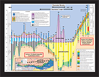
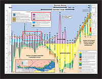
 | 10.13:
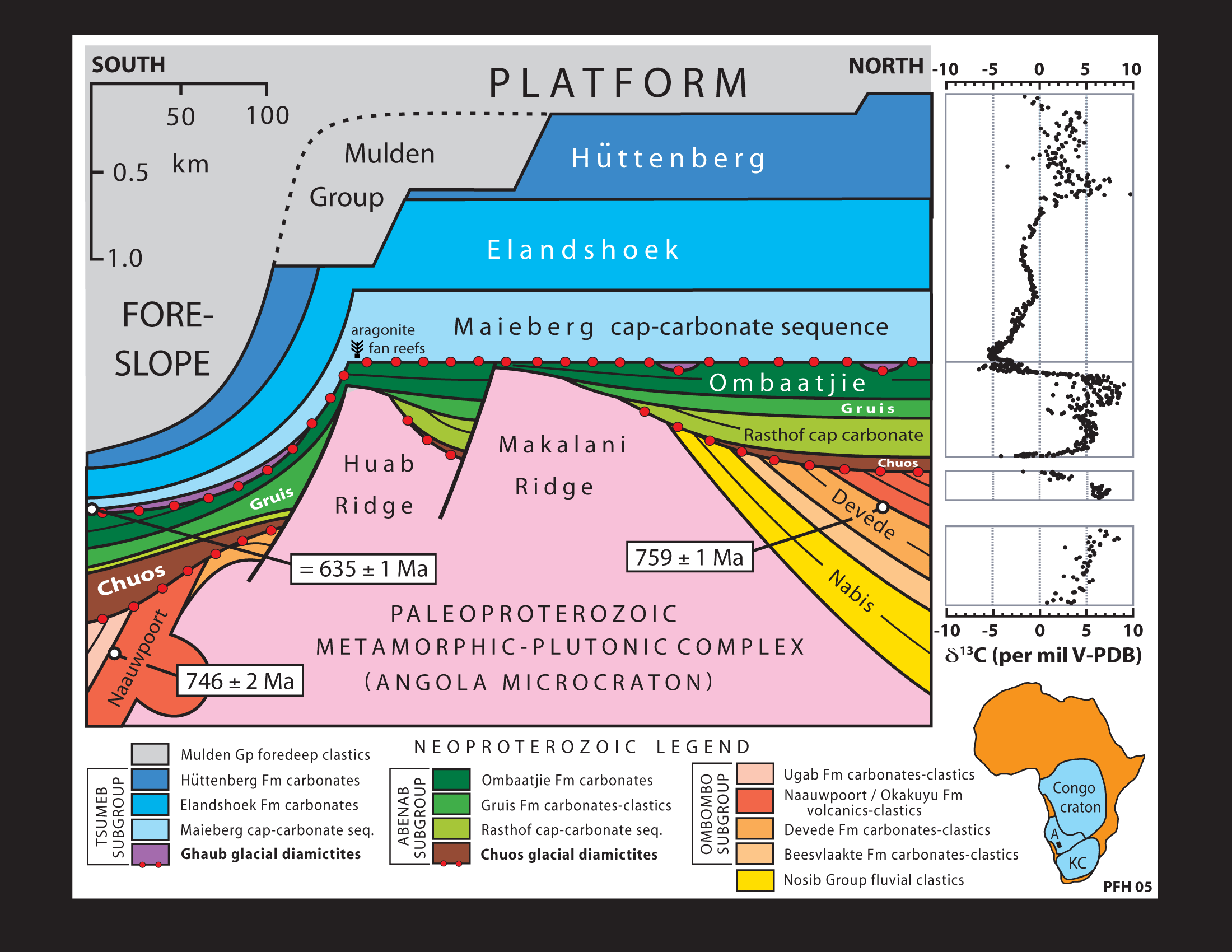
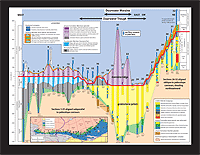
Stratigraphic restoration of the Otavi Group carbonate platform and foreslope,
Namibia, and representative carbon isotopic records of the platformal succession
(Halverson et al., 2005; Hoffman & Halverson, in press). Note the paired
glacial and cap-carbonate formations, Chuos-Rasthof and Ghaub-Maieberg
respectively.
|
|
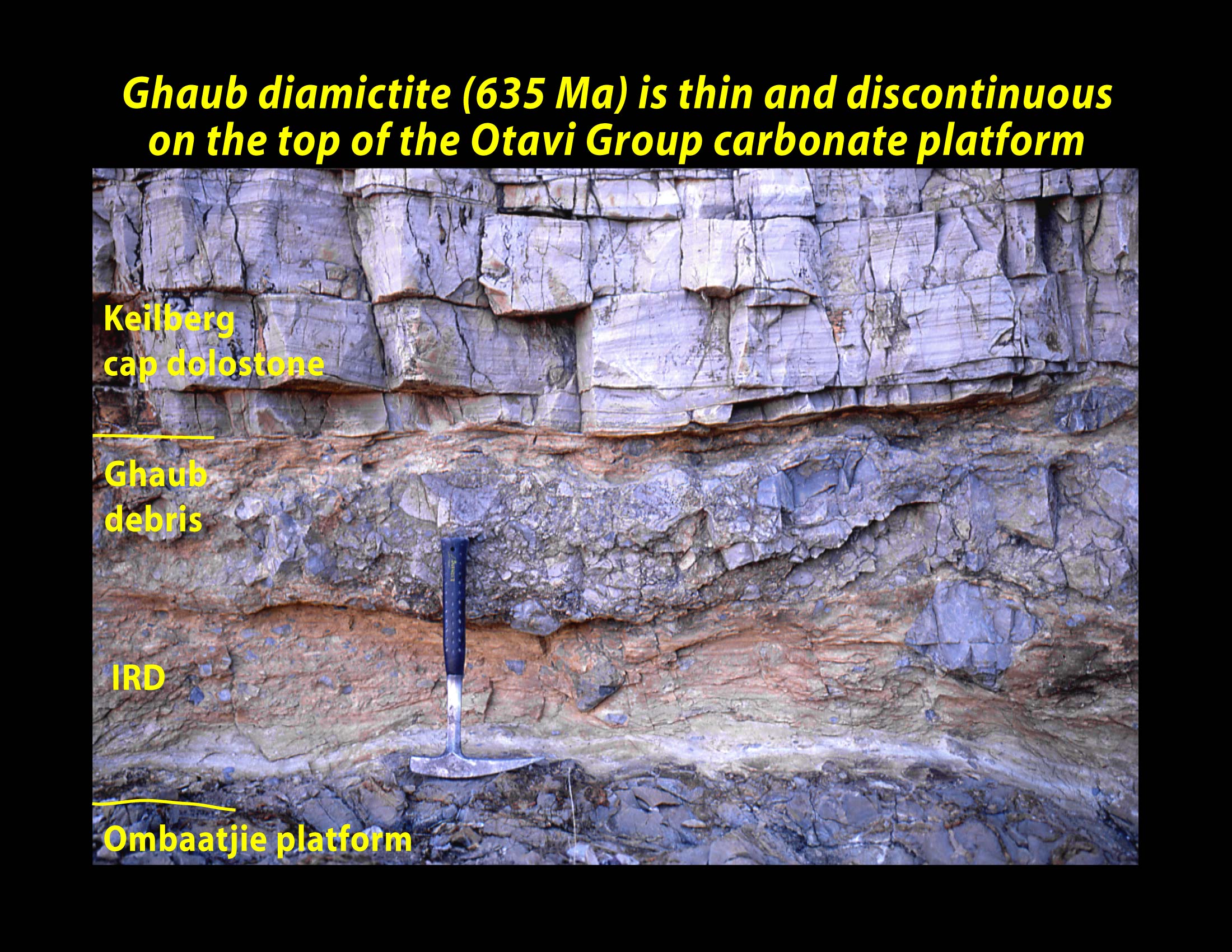
 | 10.14:
Typical thin carbonate-clast diamictite of the Ghaub Formation (635 Ma)
on the Otavi Group carbonate platform in Namibia. Diamictite paraconformably
overlies shallow-marine carbonate of the Ombaatjie Formation (hammer head),
and is conformably overlain by swaley-crossbedded, peloidal, cap dolostone
of the Keilberg Member.
|
|
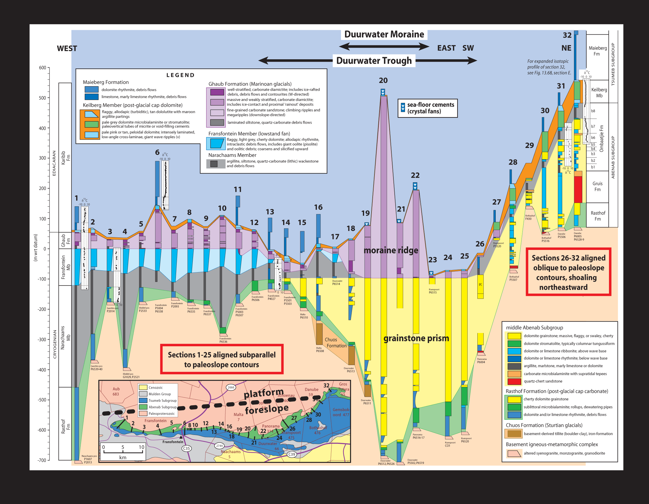
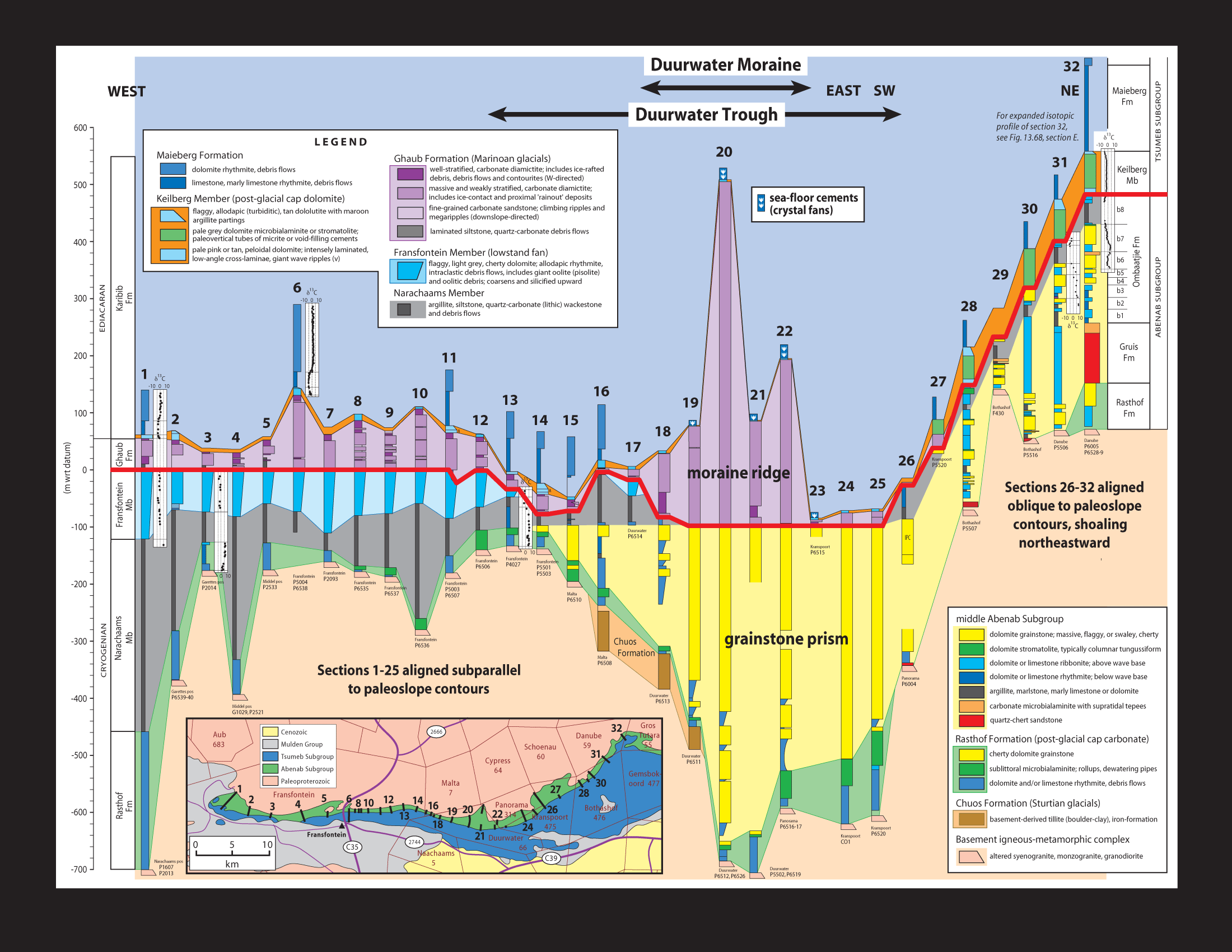
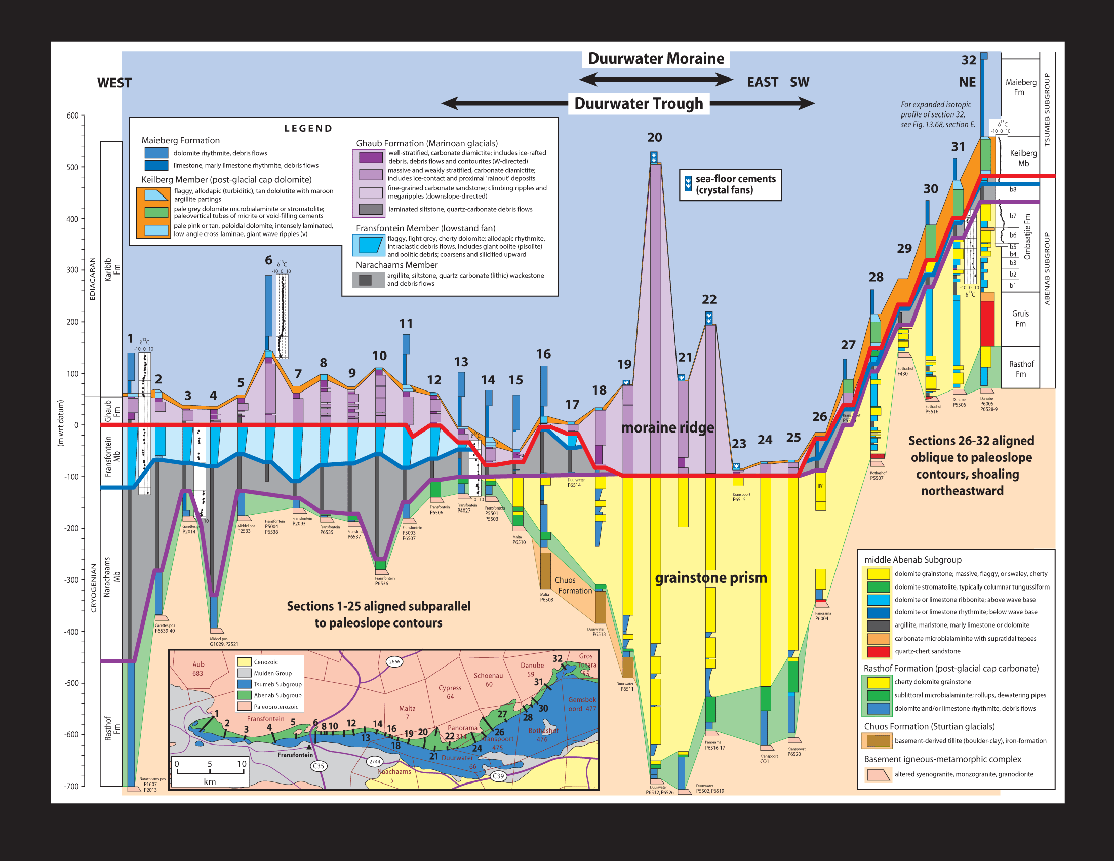
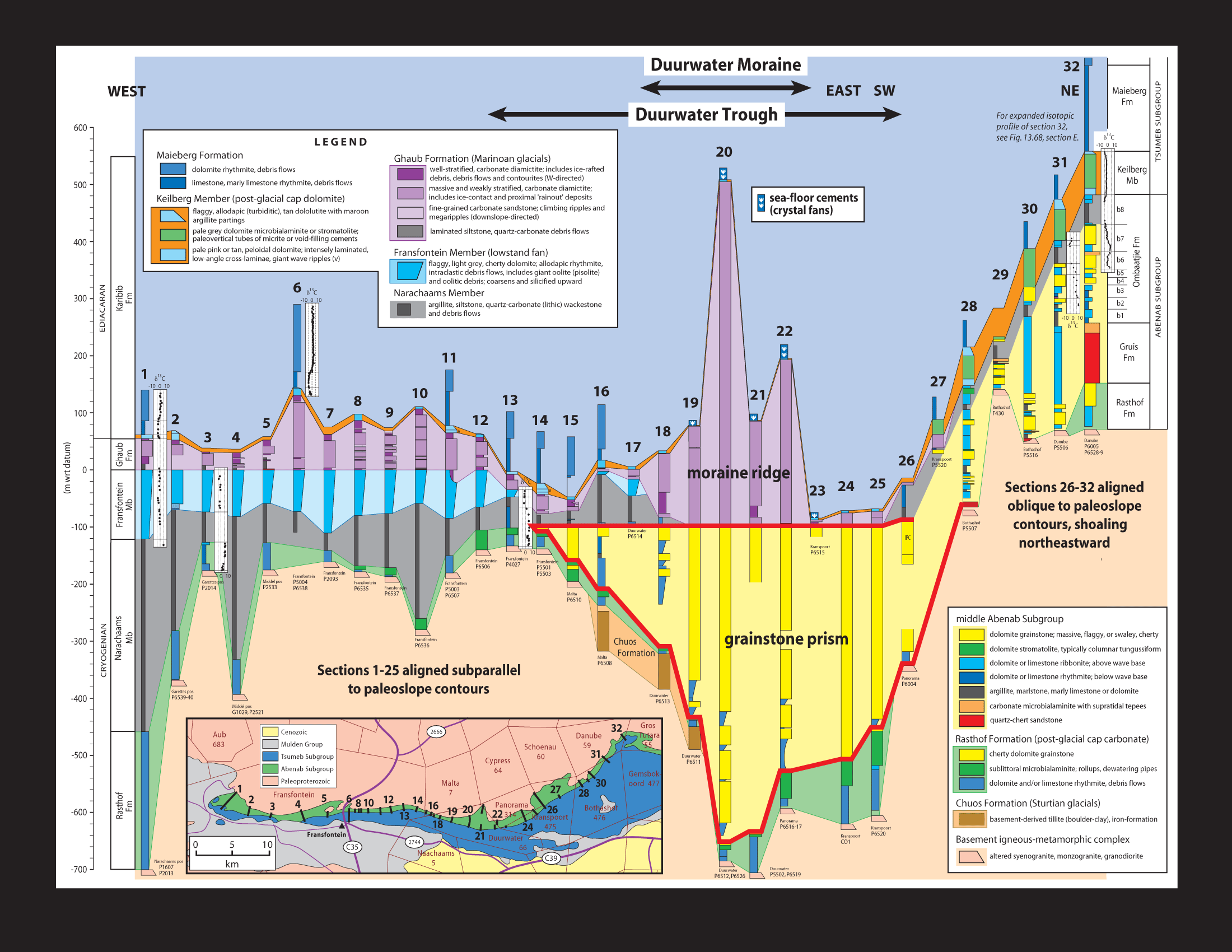
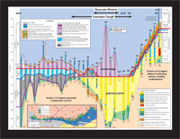
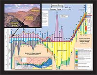
 | 10.15:
Measured columnar sections of the southern foreslope of the Otavi Group
on the Fransfontein Ridge (see inset map and slide 10-12 for location).
Line of section is 60 km long. The western 40 km is oriented subparallel
to the foreslope-platform break (heavy dashed line on inset map); the eastern
20 km angles obliquely up the foreslope to the platform edge at the easternmost
section. Columns are not fixed to a common datum but are adjusted interpretively
to suggest sea-floor topography at the end of the younger Cryogenian glaciation
(Ghaub Formation). Relief is arbitrarily suppressed at the eastern end
of the section to fit the page (from Hoffman, in press, S. Afr. J. Geol.).
|
|
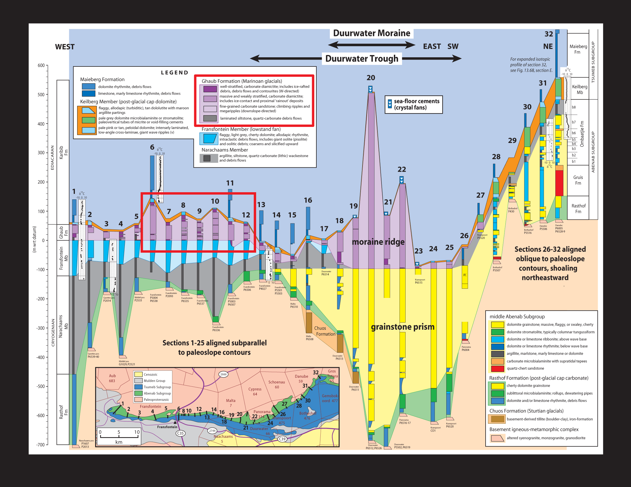
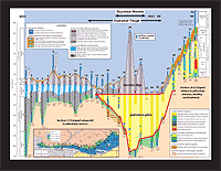
 | 10.16:
Same as last slide, but with red box indicating glacial marine sections
(Ghaub Formation) illustrated in slides 10-16 through 10-23.
|
|
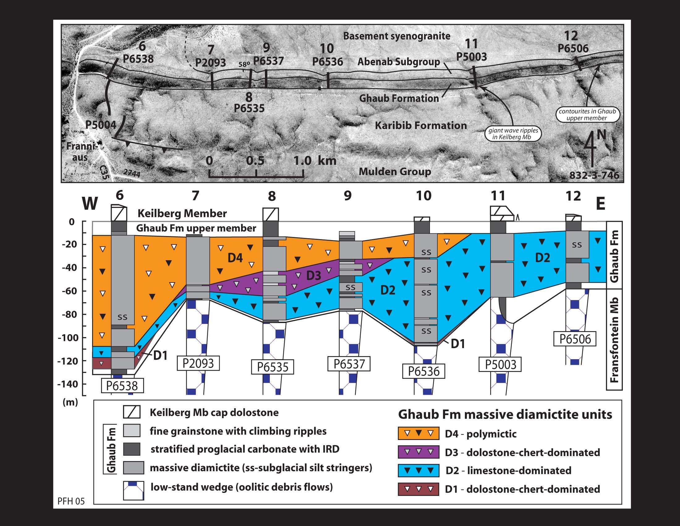
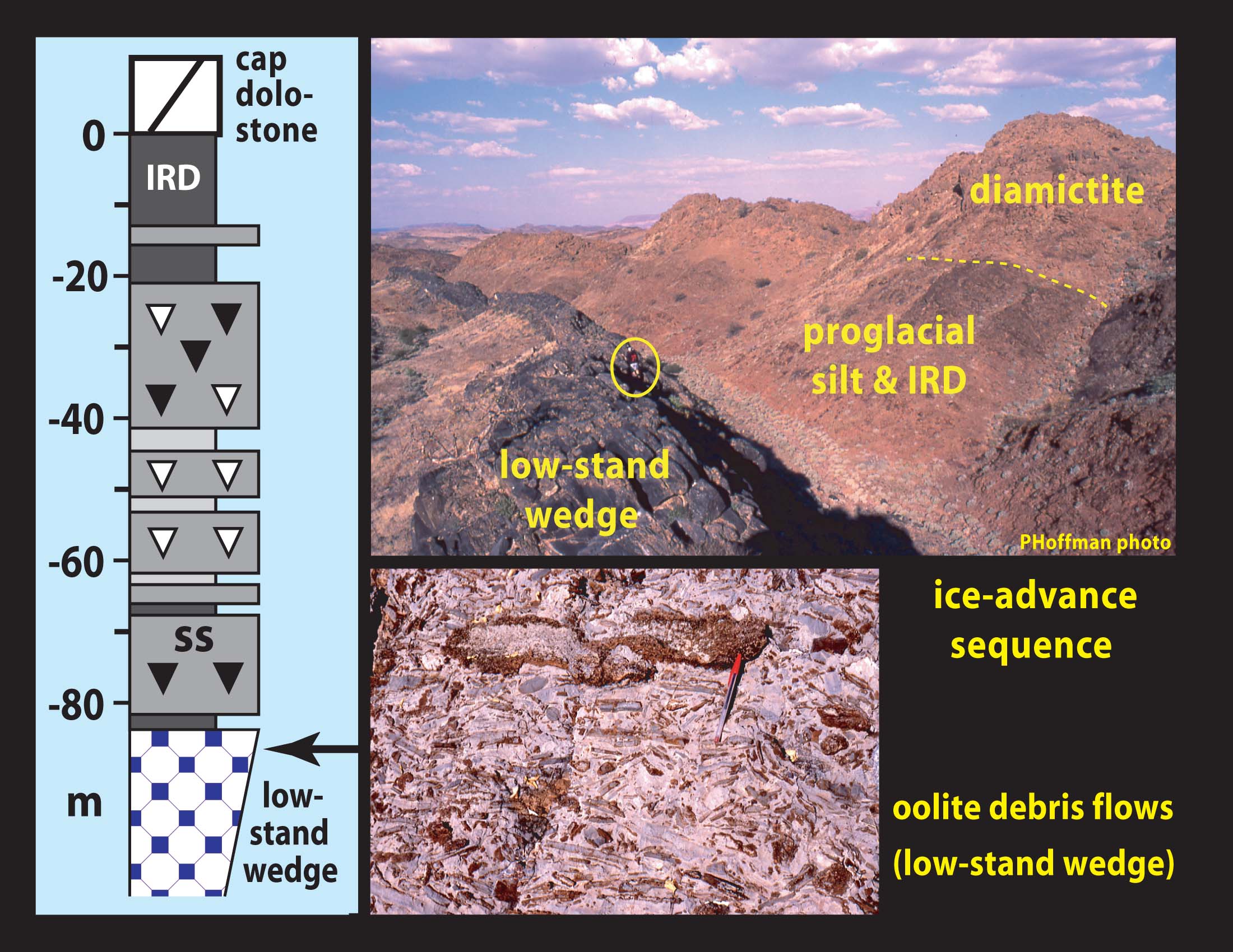
 | 10.17:
Measured sections 6-12 on the Fransfontein Ridge illustrating the stacking
of grounding-line diamictites, separated by stratified proglacial deposits,
and the interleaving of packages of lithologically-distinct diamictites.
Note continuous upper member, composed of stratified proglacial deposits
choked with ice-rafted debris (IRD).
|
|
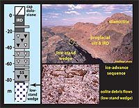 | 10.18:
On the southern foreslope of the Otavi Group, glacial marine deposits of
the Ghaub Formation are generally underlain by a low-stand wedge (Franni-aus
Member) of dolomitized rhythmite, turbidites and debris flows rich in variably-disaggregated
coarse-grained oolite, related to falling base-level accompanying ice-sheet
buildup at higher latitudes. Upper photo shows an unusually thick lower
member of the Ghaub Formation on Bethanis farm (Camp Xaragu), comprised
of terrigenous siltstone drift. IRD occurs in the transition to the massive
diamictite.
|
|
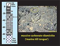 | 10.19:
Massive grounding-line diamictite composed of unsorted coarse and fine-grained
limestone (grey-black) and dolostone (tan colored) debris.
|
|
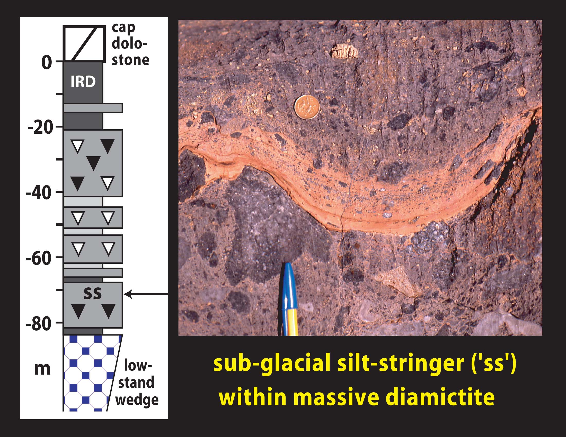
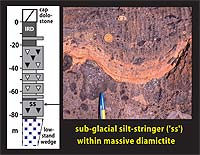 | 10.20:
Laminated “silt-stringer” with fine-grained IRD within a massive
diamictite. Silt-stringers (ss) are interpreted to have settled from suspension
in quiescent sub-glacial meltwater puddles.
|
|
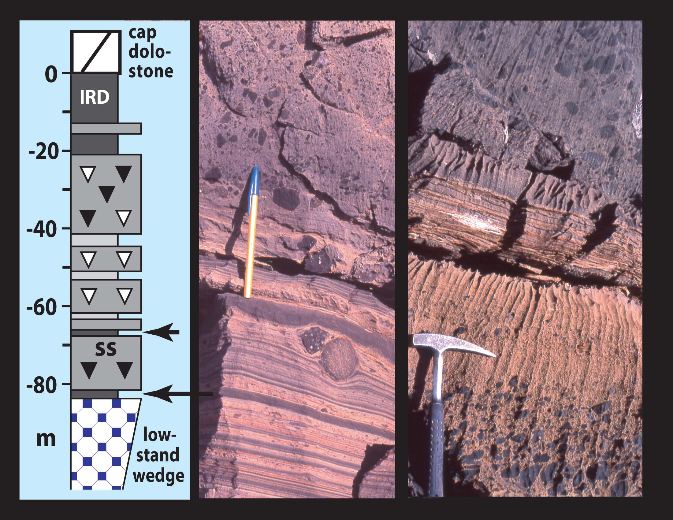
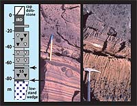 | 10.21:
(Left) Transition from proglacial sediment with IRD (lower member) into
massive limestone-clast diamictite. (Right) Stratified proglacial tongue
between massive diamictites, the lower of which is clast-size graded at
the top. Current ripples in the proglacial unit indicate paleoflow parallel
to paleoslope contours.
|
|
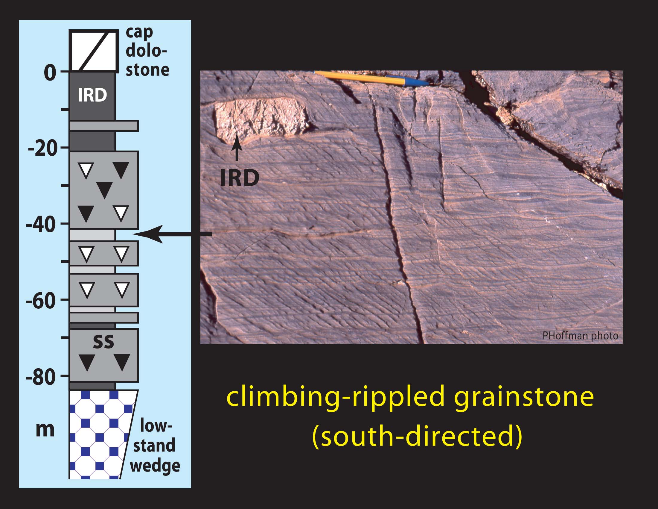
 | 10.22:
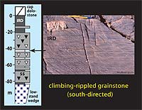
Climbing ripples with IRD in fine grainstone tongue between massive diamictites.
Paleoflow is directed southward, down the inferred paleoslope.
|
|
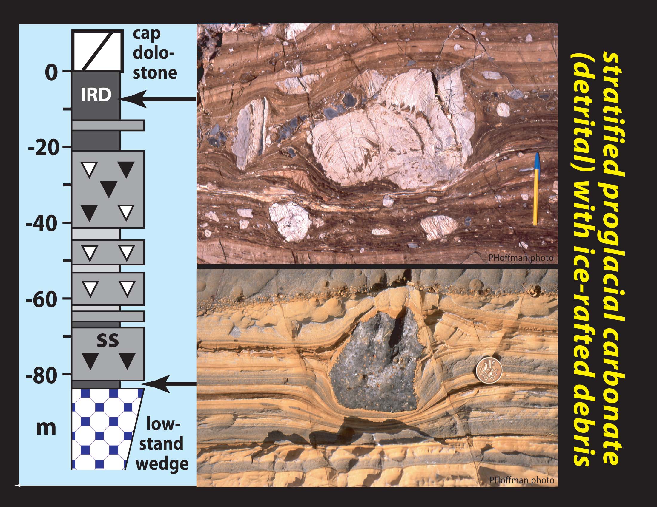
 | 10.23:
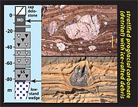
Stratified proglacial detrital carbonate with IRD in the lower (below)
and upper (above) members of the Ghaub Formation. Note deformation of impacted
strata and draping by post-impact deposits. Dropstone in lower photo is
an oolitic limestone from the Franni-aus Member; those in upper photo are
stromatolitic dolostone (pale tan) from Ombaatjie Formation cycle b7 and
limestone (dark grey) from cycle b8.
|
|
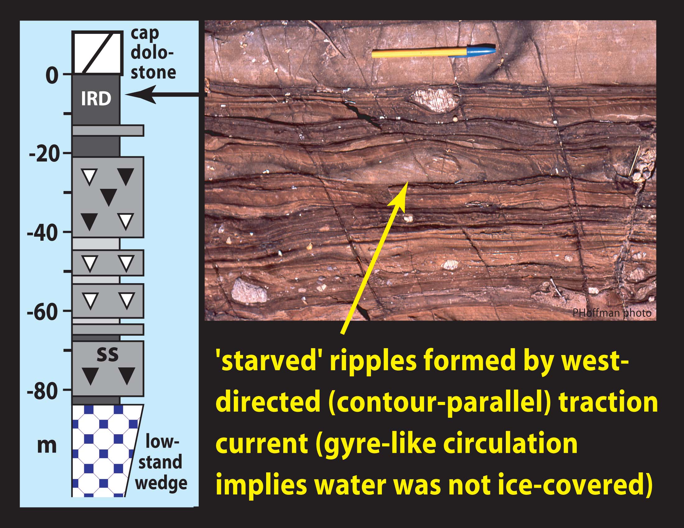
 | 10.24:
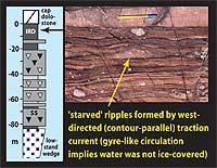
"Starved" ripple formed by westerly-directed (contour parallel)
traction currents in the proglacial upper member of the Ghaub Formation.
Gyre-like contour currents imply that waters south of the Otavi Group platform
were not perpetually ice-covered.
|
|
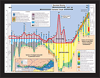
 | 10.25:
Sub-glacial erosion surface (red line) beneath the Ghaub Formation in sections
1-27 and beneath the Keilberg post-glacial cap dolostone in sections 28-32,
where glacials are absent.
|
|
 | 10.26:
Same as last slide but showing truncation by the sub-glacial erosion surface
of underlying units: (blue line) base of low-stand wedge (Franni-aus Member),
(purple line) base of terrigenous siltstone (Narachaams Member), and correlative
horizons in sections 26-32. Note broad trough cut from underlying units
by sub-glacial erosion between sections 13 and 26. Duurwater Trough is
~100 m deep (relative to underlying strata) and ~18 km wide (in the line
of section). It is interpreted to be a slope-transverse erosional feature,
possibly cut by a paleo-ice stream.
|
|
 | 10.27:
Same as last slide but indicating the extent of a major prism (outlined
in red) of dolomitized grainstone interpreted as submarine channel and
levee deposits, situated stratigraphically beneath the postulated ice-stream
trough. The prism represents a major submarine drainage system, established
well before the Ghaub glaciation apparently in response to a local subsidence
anomaly.
|
|
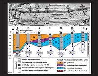
 | 10.28:
Lateral variation in thickness of the Ghaub Formation glacial marine deposits
(outlined in red): 40-135 m west of Duurwater Trough, absent on the upper
foreslope (sections 28-32), and relatively thin within Duurwater Trough
with the exception of a doubly-crested ridge of massive diamictite rising
600 m above the floor of the trough. The thickest diamictite sections (20
and 22) consist of lithologically-variable diamictites without silt-stringers
or proglacial strata. The ridge is 7.5 km wide at its base in the line
of section, giving it a minimum aspect ratio of 0.08 (0.6/7.5) assuming
transverse orientation. It is interpreted to be a transverse medial moraine
(Duurwater Moraine) possibly related to the paleo-ice stream that carved
the trough in which it resides.
|
|
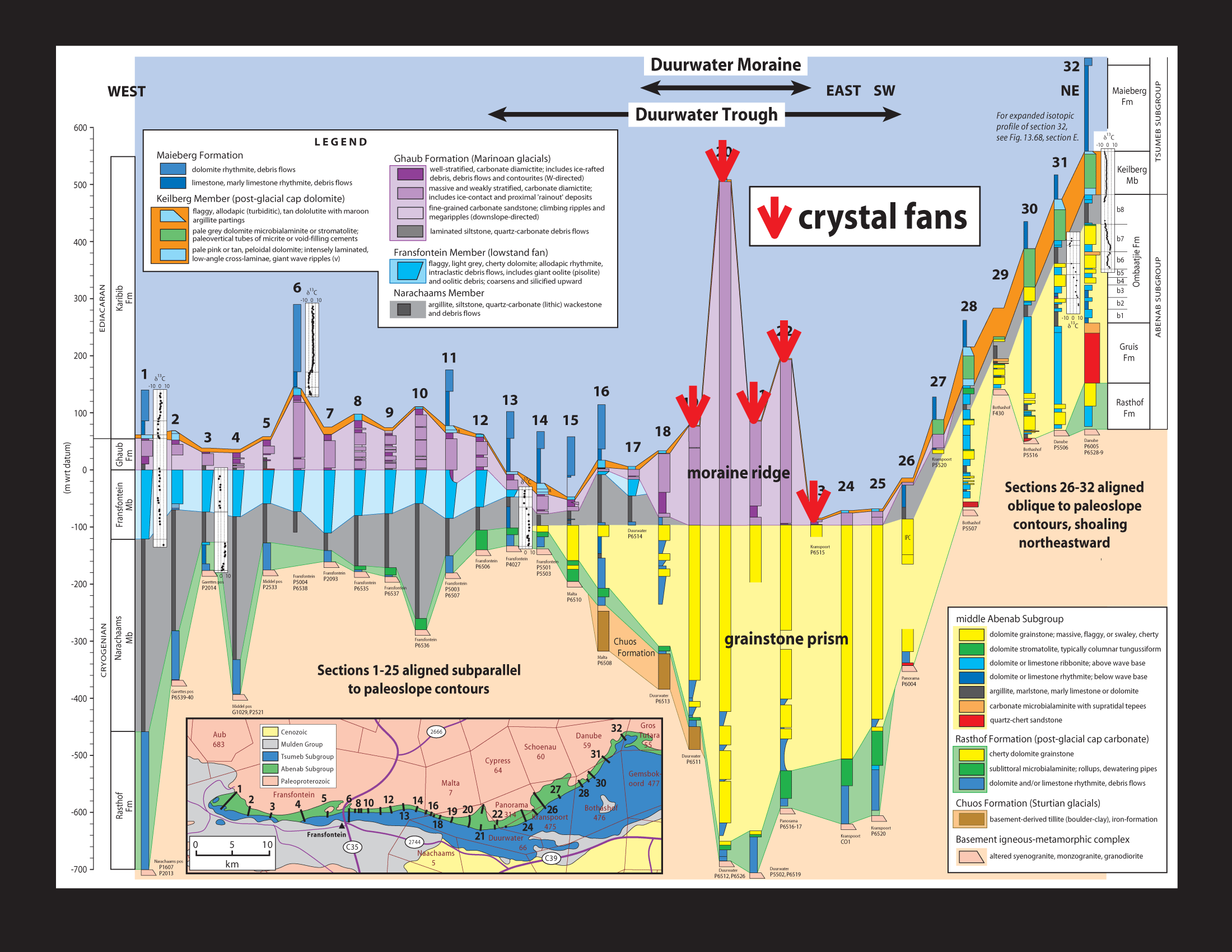
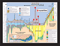 | 4.29:
Former aragonite crystal fans (sea-floor cement) occur in marly limestone
rhythmite directly above the post-glacial cap dolostone (Keilberg Member)
exclusively on the crest and flanks of the Duurwater Moraine on Fransfontein
Ridge (they occur elsewhere locally on the platform, particularly its outer
edge). The crystal fans suggest that bottom waters were highly oversaturated
with respect to CaCO3, and may be related to shoaling and vertical
mixing associated with the sea-floor topography.
|
|
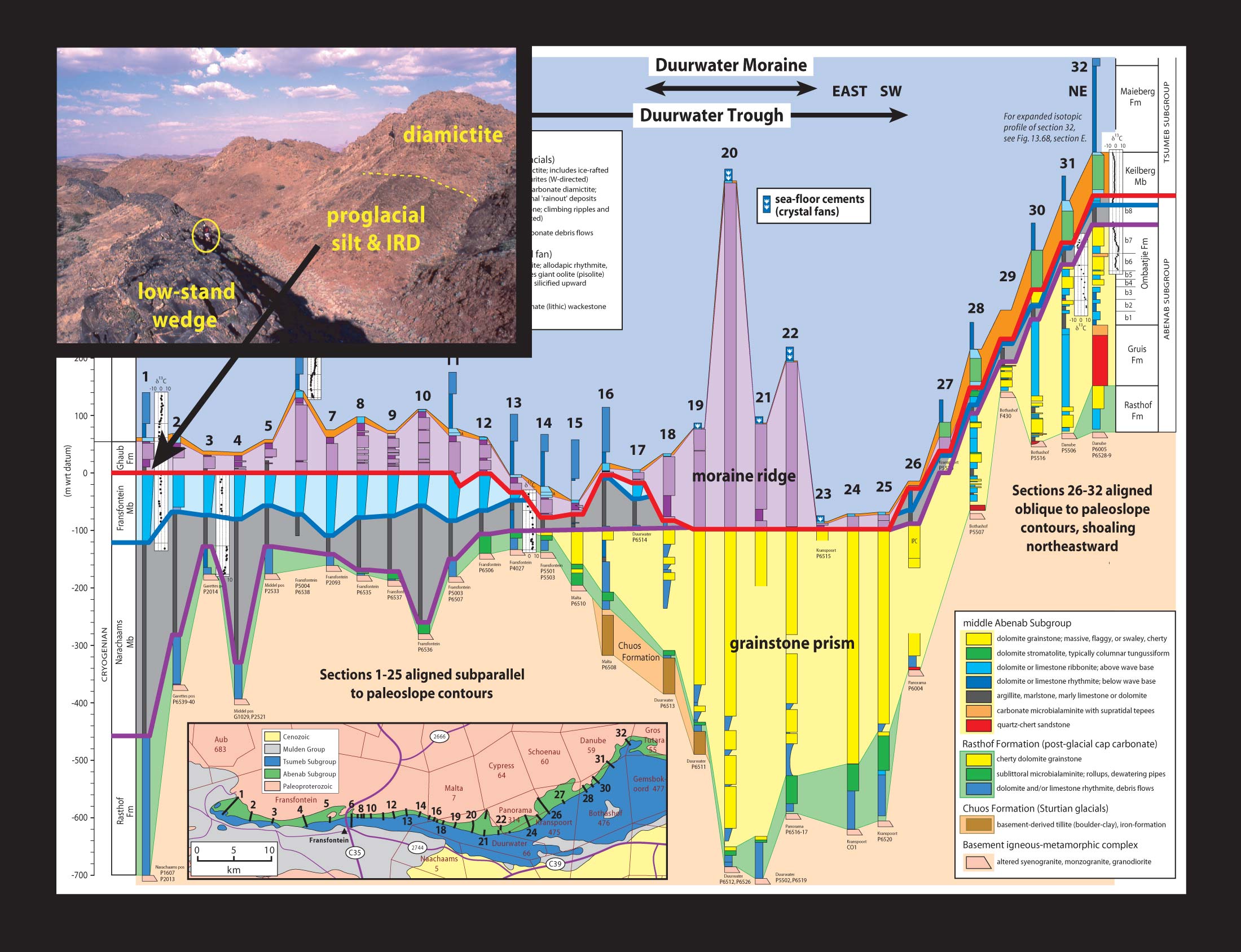
 | 4.30:
Terrigenous silt (with rare outsize quartz granules) in the lower member
is the only significant terrigenous component in the Ghaub Formation glacial
marine deposits. Its logical source is the lithologically identical siltstone
(locally with quartz granules) of the Narachaams Member, which was exposed
by the erosion of Duurwater Trough. It follows that the trough was eroded
before the basal Ghaub Formation was deposited. If the trough was eroded
by an ice stream at the glacial maximum (or maxima), then the Ghaub Formation
consists entirely of recessional deposits. Conditions recorded by the Ghaub
Formation do not represent glacial maximum conditions, and place no constraint
on the extent or thickness of ice cover on the adjacent ocean during the
glacial maximum.
|
|
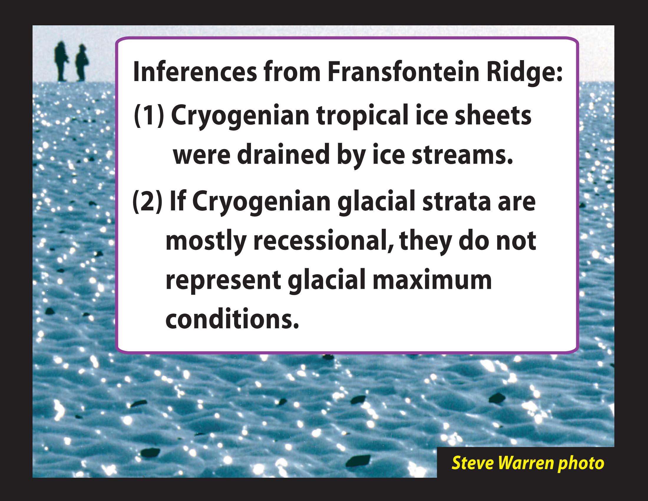
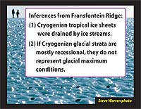 | 10.31:
Inferences from glacial sedimentology on Fransfontein Ridge. Background
photo is from the ablative zone of the Antarctic Ice Sheet (photo courtesy
of Steve Warren).
|
|
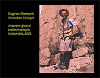 | 10.32:
Thanks to Eugene Domack for glacial sedimentological insights and an open
mind. He stands on the contact between Ghaub diamictite and the Keilberg
cap dolostone, with his hands near the base of the plumb (tubular) stromatolite
biostrome.
|